Day 20 - San Gorgonio Mountains
Lots of people I camped with left earlier than me, motivated by In and Out Burger in Cabazon. I just wasn't interested in getting a long hitch into town just for salad and fries. Also, the resupply there is just a gas station so I planned on continuing to Big Bear.
It was desert hiking down the valley to Cabazon, without trees or even many large bushes for cover. At the I 10 bridge, there were bananas and Tootsie Rolls. I grabbed a few candies and ate a couple bananas.
I lost the trail a little in a wash, but soon figured it out. The trail is hard to follow through here, because the San Gorgonio River (currently dry), washes through here. You have to follow a series of yellow poles in a sea of yellow desert flowers. Easy.
The trail winds its way up from the valley, going into the foothills of the San Gorgonio Mountains. The wind was blowing hard, but not as bad as the day before. The windmills were ahead on the hills above. I stopped at the Mesa Verde Wind Farm office, there's one guy there and he leads me back to the break room, tells me to help myself to water and cake in the refrigerator. Cake! I'm going to have to make another exception. I'm hungry. The cake is from someone'sbirthday party, looks fresh and there's three slices left. The cake has large stripes of black icing, which stains everything it touches, like my mouth, tongue and fingers. I drink a bottle of water with the cake, leaving a donation in the can. They were nice, but obviously they have a business to run so they're not going to hang out and talk.
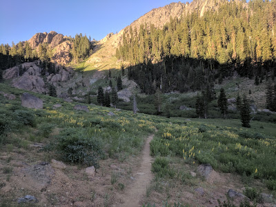
Shortly after the wind farm office, the trail starts climbing steeply for a short time. On the other side of the saddle, the vegetation changes from cacti and low bushes to dry grasses blowing in the wind, with the occasional Manzanita bushes to break it up. There are rugged cliffs and it's unlike anything I've ever seen. The trail undulates through this wild territory, the San Gorgonio Wilderness. Up and over a series of ridges. I can see hikers far ahead of me. Rounding one hill, I hear rushing water below. It's the Whitewater River. I stop to take in the view and Giggles catches up to me. Shes moving quick, heading for the Whitewater Preserve where rangers let you charge your devices, there's restrooms and grass to camp on.
When I arrive, Daniel is there! I'm so glad to see him again. Apparently he passed me while I was lost back on Marion Mountain Trail. He also has a new trail name, Mouse. He's been hiking with Joe and the group of Australian women. One of them gave him the trail name, since he's quiet and he doesn't eat much. It suits him.
We hang out and I charge my phone and GPS unit. I want to go hike 6 more miles, a lot of people are staying here.
As we left, we ran into Cliff Walker and Stakes, who are going to camp at Whitewater. I haven't seen them since Warner Springs and I thought they were far ahead. We actually did 2 more miles and camped right before the ford of the river. The river is not very big, maybe 10 feet across at the widest. It's not deep enough to be dangerous either.
I met Rich, a nice guy who loves his grandkids camped near. The group of four veterans are also camped nearby, we can see them throwing rocks into the river.
We cowboy camped in a sandy spot between a red rock cliff and the river. The sunset was amazingly beautiful, pink clouds reflecting off the river.
It was desert hiking down the valley to Cabazon, without trees or even many large bushes for cover. At the I 10 bridge, there were bananas and Tootsie Rolls. I grabbed a few candies and ate a couple bananas.
I lost the trail a little in a wash, but soon figured it out. The trail is hard to follow through here, because the San Gorgonio River (currently dry), washes through here. You have to follow a series of yellow poles in a sea of yellow desert flowers. Easy.
The trail winds its way up from the valley, going into the foothills of the San Gorgonio Mountains. The wind was blowing hard, but not as bad as the day before. The windmills were ahead on the hills above. I stopped at the Mesa Verde Wind Farm office, there's one guy there and he leads me back to the break room, tells me to help myself to water and cake in the refrigerator. Cake! I'm going to have to make another exception. I'm hungry. The cake is from someone'sbirthday party, looks fresh and there's three slices left. The cake has large stripes of black icing, which stains everything it touches, like my mouth, tongue and fingers. I drink a bottle of water with the cake, leaving a donation in the can. They were nice, but obviously they have a business to run so they're not going to hang out and talk.
Shortly after the wind farm office, the trail starts climbing steeply for a short time. On the other side of the saddle, the vegetation changes from cacti and low bushes to dry grasses blowing in the wind, with the occasional Manzanita bushes to break it up. There are rugged cliffs and it's unlike anything I've ever seen. The trail undulates through this wild territory, the San Gorgonio Wilderness. Up and over a series of ridges. I can see hikers far ahead of me. Rounding one hill, I hear rushing water below. It's the Whitewater River. I stop to take in the view and Giggles catches up to me. Shes moving quick, heading for the Whitewater Preserve where rangers let you charge your devices, there's restrooms and grass to camp on.
When I arrive, Daniel is there! I'm so glad to see him again. Apparently he passed me while I was lost back on Marion Mountain Trail. He also has a new trail name, Mouse. He's been hiking with Joe and the group of Australian women. One of them gave him the trail name, since he's quiet and he doesn't eat much. It suits him.
We hang out and I charge my phone and GPS unit. I want to go hike 6 more miles, a lot of people are staying here.
As we left, we ran into Cliff Walker and Stakes, who are going to camp at Whitewater. I haven't seen them since Warner Springs and I thought they were far ahead. We actually did 2 more miles and camped right before the ford of the river. The river is not very big, maybe 10 feet across at the widest. It's not deep enough to be dangerous either.
I met Rich, a nice guy who loves his grandkids camped near. The group of four veterans are also camped nearby, we can see them throwing rocks into the river.
We cowboy camped in a sandy spot between a red rock cliff and the river. The sunset was amazingly beautiful, pink clouds reflecting off the river.

Comments
Post a Comment