Uwharrie Trail Backpacking Trip
 |
| Pretty little creek in Uwharrie |
 |
| Roscoe rolls in leaves every time we take off his pack. |


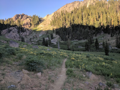
The trail climbs significantly the first mile, quickly bringing you up to the mountains. All the views are through the trees, but with the leaves off it's beautiful. There are lots of quartz and granite rocks protruding from the ground. No one else is around. Solitude.
When we get closer to the midpoint of the trail, we see a large group of boy scouts, and two day hikers with two dogs. There are very few flowers, just one redbud blooming and a few wildflowers here and there. It's a little behind Raleigh due to the higher elevation.
During our lunch break we got off the trail a bit and let Roscoe off leash. He has a great roll in the leaves after his pack comes off, but he mostly just lays next to me staring at my food. Until he hears something in the woods and runs to investigate.
We take a dinner break by a pretty creek, but we've still got 5 miles to hike before get the 14 I'm aiming for in a day. 14 miles seems a lot longer here than the 17 at Falls Lake. There's also some disagreement between Ian's GPS watch and the mileage listed on the map. His watch has a whole extra mile in those first 7 miles! We decide to go by the map mileage because an extra mile is just extra training.

 |
| The log crossing |
Continuing on, it wasn't long before we reached a creek crossing with just a simple log as a “bridge”. Ian and Roscoe I walked across it, no problem. I really don't like heights, or crossing on logs. I decided to get straddle the log and scoot across. This has got to be the most annoying way to cross a creek. I think I'd rather wade through. It takes so long, a few inches at a time and you've got your pack exaggerating every movement with all its weight.
 |
| He'll do anything for a peanut. |
 |
| Trail food! |
We kept hiking into the dark again. My little Petzl e-lite was good enough this time to not slow me down. It's all relative with light. There was so much ambient light on the Falls Lake hike from being closer to civilization that the little light was not bright enough. Out in Uwharrie there is less light so that little light was enough.
We hike on in the dark on a moonless clear night, the stars shining brightly above. I wish I had practiced my night photography, but there weren't really any clearings for it. Might have gotten a looking up into the trees shot.
Lots of moisture and fog in the air at Dutchman's Creek and a few campers next to the creek. Soon after we came to a few burned areas. We reach 15 miles on Ian's GPS and go off trail a little, find a flat spot and pitch the tent. We're all beat. Roscoe curls up in the leaves. He's done. Once we've got the sleeping gear set up, it doesn't take much convincing to get him in the tent.
I fall asleep with doubts about thru hiking the PCT running through my mind. What am I doing? I haven't spent enough time out in the backcountry to know if I'd like it for months. I'm so slow. Can I do this?

 |
| Tired dog. |

The moon rose in the early morning, so bright it wakes me up shining through the thin cuben fiber tent. The wind picks up. I think about the way the Zpacks Duplex tent has all the ventilation at the bottom. I think this may make it a colder tent than our REI Quarter Dome 2 Plus since the air is running over your body. However, it likely deals with condensation from our breath better also. You can't beat the weight savings! This tent weighs 1 lb 7 ounces, stakes included, and uses my trekking poles for structure.
The sun isn't over the hill yet, but it's bright at 7:30, so we pack up. I wonder where my Kindle is, worried. It's in my pack. Maybe too many things are slowing me down.
Hiking back out the way we came, we’re not super impressed by the scenery in this section. Lots of recently burned areas. Said good morning to the campers by the creek while they had their breakfast. Passed lots of muddy areas by creeks. Briefly talked to two day hikers or runners stopped at an intersection. Roscoe said hello with his tongue.
We reached the log bridge I wimped out on the day before. Ian was very encouraging. Roscoe was all about crossing the log and went first. Then Ian crossed with my camera and photographed me. The first part of the log was the worst, it was narrow and not completely straight, so instead of being able to just get up some speed and go, I was starting slow. I was really nervous about it, but I kept moving. I did it! I don't know when I turned into such a wimp about crossing streams, I used to cross them all the time as a kid. We'd play games seeing who could do what crossing. My siblings were usually better at it than me, though. Hopefully I get better at this and more confidant on crossings.
Today we decided to give the hiking a little more structure. We'd hike 4 miles, take a long break, then 5 miles, take a long break, then another 5 to the car. We stopped at a nice creek campsite for the first long meal break. I would call this our breakfast, but, really, we had been eating the whole time. A perk of backpacking, you graze constantly on snacks like trail mix, granola bars, dried fruit and seitan jerky.
 |
| Roscoe says its super easy. |
 |
| I did it! |
 |
| Roscoe explores rocks. |
 |
| A real bridge! |
We hiked on, back through the same scenery. It was a really beautiful Sunday afternoon and the day hikers were out and it seemed all of them had brought their dog. We had to stop many times to pull Roscoe off the trail. He's not a big fan of other dogs and this behavior seems amplified by being in the woods. He's a pain sometimes, but he is making progress.
Ian had the map for this trip. He decided to skip the big stream and wait until we got to a smaller stream on the map to fill up. I had a good amount of water since I was simulating a desert water carry worth of weight but I hadn't filled up since the day before. When we got to the stream, it didn't look promising. It was mostly dry with a few still pools of water. It's less safe to get water out of a still pool. We got off trail and followed the stream down a little way. It quickly turned into a proper stream with running water. I was glad we didn't have to go too far off trail.
I love using chemical treatment rather than a pump. Ian spent almost the entire 45 minute break backflushing his pump and then pumping the water through the filter. I spent about ten minutes getting water and was able to relax with my shoes off, reading a book on my Kindle the rest of the time. His water does taste better, though. Especially when you're in a more pristine area drinking from a spring. It's the best water you'll ever taste. The Aqua Mira chemical treatment tastes a little like lemon water to me.
While we rested, I kept hearing this weird noise, sounded like the flap of a large bird taking off when startled, but e kept hearing it from the same place. I kept looking and couldn't figure it out. Ian finally realized it was two trees rubbing together in the wind! When the wind blew, one would get pressed against the other and when the wind stopped, it would release and make that noise.

 |
| Grayson's Rock |
 |
| Summit picture practice. |
On the way out, we noticed a laminated sign we had missed on the way in. Someone had tripped and hit their head “summiting” a small boulder here. They're fine, just a scar, but it looks like a good friend wanted to have a little fun with it and posted this note. So, of course, I summited the formidable Grayson's Rock and Ian snapped a shot.
That's about it, except we ended up following the trail to the end and it was not where we parked. If we had gone around the next corner on the road, there was a large parking lot with a sign, map, trash cans and everything. I've gotten used to Pisgah, where any space large enough to park a Smart car can be called a parking area and trails are often not marked at all or signs are stolen. What luxury!
That's about it, except we ended up following the trail to the end and it was not where we parked. If we had gone around the next corner on the road, there was a large parking lot with a sign, map, trash cans and everything. I've gotten used to Pisgah, where any space large enough to park a Smart car can be called a parking area and trails are often not marked at all or signs are stolen. What luxury!

Comments
Post a Comment